


PhoneMaps
คำอธิบายของPhoneMaps
Mobile phone app PhoneMaps offers FOR FREE zoomable hiking and cycling maps with full network of marked hiking and cycling routes of almost whole Europe. In app you can plan your holiday, during the activity orientate in terrain and record your tracks and experiences and then share them with your friends. Hiking or cycling content with marked hiking/cycling routes you will not find in general map applications in your phone, you will not need to go to bookshop and buy paper map.
- Language: English, German, Czech, Slovak, Polish, Italian, Chinese
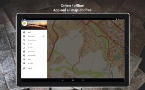
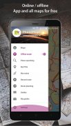
- Online and offline maps
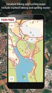
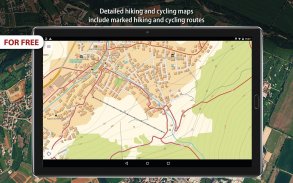
- Detailed hiking and cycling maps include marked hiking and cycling routes
- Maps created by cartographic companies freytag&berndt and SHOCart
- Hiking and travel guides from Bergverlag Rother, freytag&berndt
- Vector maps: smaller, can be easily zoomable and rotated
- Download map of area where you will go, map tiles are displayed as one map
- All points in maps with interactive information (address, website, email, timetable, ....)
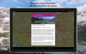
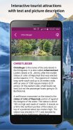
- Interactive tourist attractions in maps (photos and texts)
- Current GPS position
- Locality searching
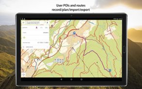
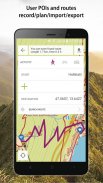
- Record/import/export/management of user routes (gpx)
- Record user Points of interest
- Spatially localized taking photos in app
- Online routing and searching of optimal routes in a map (for hikers, cyclers, cars)
- Statistics of routes + elevation models of routes
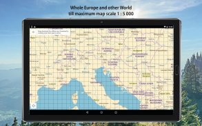
- Hiking / cycling map till 1:5 000 - Andorra, Austria, Belgium, Bulgaria, Croatia, Czech Republic, Denmark, Estonia, Finland, France, Germany, Greece, Ireland, Israel, Italy, Hungary, Latvia, Lichtenstein, Lithuania, Luxembourg, Monaco, Montenegro, Netherlands, Norway, Poland, Romania, San Marino, Spain, Slovakia, Slovenia, Sweden, Switzerland, United Kingdom, USA, Nepal, Japan, Taiwan, New Zealand, Israel, Kilimanjaro
- Topographic map 1:5 000 - rest of the world
AND THE BEST THING IS THAT APP AND ALL MAPS AND FUNCTIONS IN APP ARE FOR FREE!
แอพโทรศัพท์มือถือ PhoneMaps เสนอแผนที่เดินป่าและขี่จักรยาน zoomable ฟรีพร้อมเครือข่ายเส้นทางเดินป่าและเส้นทางจักรยานเกือบเต็มรูปแบบในยุโรปเกือบทั้งหมด ในแอพคุณสามารถวางแผนวันหยุดของคุณในระหว่างที่กิจกรรมอยู่ในภูมิประเทศและบันทึกแทร็กและประสบการณ์แล้วแชร์กับเพื่อน ๆ ของคุณ เนื้อหาการเดินป่าหรือขี่จักรยานที่มีเส้นทางเดินป่า / ขี่จักรยานที่มีเครื่องหมายคุณจะไม่พบในแอปพลิเคชันแผนที่ทั่วไปในโทรศัพท์ของคุณคุณไม่จำเป็นต้องไปที่ร้านหนังสือและซื้อแผนที่กระดาษ
- ภาษา: อังกฤษ, เยอรมัน, เช็ก, สโลวัก, โปแลนด์, อิตาลี, จีน
- แผนที่ออนไลน์และออฟไลน์
- แผนที่เดินป่าและขี่จักรยานโดยละเอียดรวมถึงเส้นทางเดินป่าและเส้นทางจักรยาน
- แผนที่ที่สร้างขึ้นโดย บริษัท cartographic freytag & berndt และ SHOCart
- คู่มือเดินป่าและการเดินทางจาก Bergverlag Rother, freytag & berndt
- แผนที่เวกเตอร์: เล็กลงสามารถซูมและหมุนได้อย่างง่ายดาย
- ดาวน์โหลดแผนที่ของพื้นที่ที่คุณจะไปแผ่นแผนที่จะแสดงเป็นแผนที่เดียว
- ทุกจุดในแผนที่พร้อมข้อมูลแบบโต้ตอบ (ที่อยู่เว็บไซต์อีเมลตารางเวลา .... )
- สถานที่ท่องเที่ยวเชิงโต้ตอบในแผนที่ (ภาพถ่ายและข้อความ)
- ตำแหน่ง GPS ปัจจุบัน
- การค้นหาท้องที่
- บันทึก / นำเข้า / ส่งออก / การจัดการเส้นทางผู้ใช้ (gpx)
- บันทึกคะแนนผู้ใช้ที่น่าสนใจ
- การถ่ายภาพในแอป
- การกำหนดเส้นทางออนไลน์และการค้นหาเส้นทางที่ดีที่สุดในแผนที่ (สำหรับนักเดินทางไกลนักปั่นจักรยานรถยนต์)
- สถิติเส้นทาง + รูปแบบการยกระดับของเส้นทาง
- แผนที่เดินป่า / ขี่จักรยานจนถึง 1: 5 000 - อันดอร์ราออสเตรียเบลเยี่ยมบัลแกเรียโครเอเชียสาธารณรัฐเช็กเดนมาร์กเอสโตเนียฟินแลนด์ฝรั่งเศสเยอรมันนีกรีซกรีซไอร์แลนด์อิสราเอลอิสราเอลอิตาลีลัตเวีย Lichtenstein ลิทัวเนีย ลักเซมเบิร์ก, โมนาโก, มอนเตเนโก, เนเธอร์แลนด์, นอร์เวย์, โปแลนด์, โรมาเนีย, ซานมารีโน, สเปน, สโลวะเกีย, สโลวีเนีย, สวีเดน, สวิตเซอร์แลนด์, สหราชอาณาจักร, สหรัฐอเมริกา, เนปาล, ญี่ปุ่น, ไต้หวัน, นิวซีแลนด์, อิสราเอล, คิลิมันจาโร
- แผนที่ภูมิประเทศ 1: 5 000 - ส่วนที่เหลือของโลก
และสิ่งที่ดีที่สุดคือแอปและแผนที่และฟังก์ชั่นทั้งหมดในแอปฟรี!
PhoneMaps--เวอร์ชั่น99.0
(14-04-2020)PhoneMaps - ข้อมูล APK
เวอร์ชั่น APK: 99.0แพ็คเกจ: eu.phonemapsเวอร์ชั่นล่าสุดของPhoneMaps
เวอร์ชั่นอื่น


แอปในประเภทเดียวกัน


